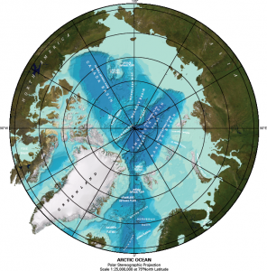
- Geodesy and Spatial Referencing – GSR
-
Content outline:
- The part devoted to geodesy (geometrical, physical, map projections) is, in view of the entry requirements, a refreshing module.
- The Least square theory, with example of usage in hydrography is detailed in the second part.
- A refreshing module on land surveying with focus to hydrographic measurements is done in the third part.
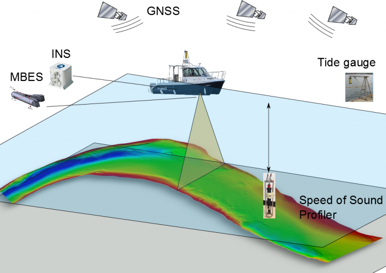
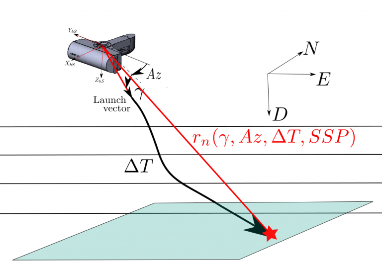
- It is followed by a comprehensive study of spatial referencing of mobile survey systems hybrid measurements (Positioning, Plateform attitudes, range measurement by single and multibeam echo sounders and LiDAR). This part includes a description of the different frames (local geodetic, survey plateform body frame, sensor frames) and associated transformation between these frames.
The main learning outcomes of GSR are:
- Describe geodetic reference systems in use and achieve transformations between geodetic systems;
- Perform geodetic line computation and map projections;
- Measure and adjust survey control data from angle and distance measurement devices;
- Understand mobile mapping concepts and associated frames;
- Perform data spatial referencing from hybrid measurements of position, orientation and ranging.
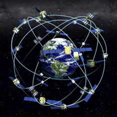
- Positioning – POS
-
Content outline:
- Global Navigation Satellite Systems (GNSS). This part presents the fundamentals of GNSS and describes the GPS, GLONASS, GALILE and BEIDOU system. The module introduce the use of RTKLIB, a free software for GNSS post-processing.
- Statistical tools details the statistical analysis of least square solution, with application to hydrographic problems.
- A detailed presentation of Inertial Navigation Systems (INS) comprises principles, practical alignement of INS, the problem of heave estimation, and INS/GNSS hybrid systems.
- Subsea positioning presents the principle of acoustic positioning , including Short baselines, Ultra Short base lines, Long base lines.
The main learning outcomes of POS are:- To operate a hybrid positioning system and to perform positioning quality control;
- To differentiate the main GNSS modes and interpret quality factor in relation to sources of errors;
- To describe the principle of acoustic positioning system, to perform LBL and USBL calibration;
- Understand the concepts of inertial navigation systems, perform the static and dynamic alignment of an INS, describe heave measurement principle and sources of errors.
- Environnement - ENV
-
Content outline:
- Physical oceanography, composition of sea water and its influence on acoustic propagation;
- Marine geology gives the fundamental of seabed composition, sediments and deposition, seabed sampling techniques;
- Marine geophysics outline the main types and applications of seismic surveys, gravity surveys, and magnetic surveys.
The main learning outcomes of ENV are:
- To understand the role of ocean physical parameters observations in support to a hydrographic survey, global/coastal ocean circulation and sediment transport principles;
- To describe magnetic and gravity surveys
- To describe seismic surveys and the role of surface and acoustic positioning.
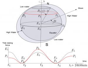
- Tides and Water Levels – TID
-
Content outline:
- Tide theory, the origin of tide raising forces, tidal regimes;
- Tide measurement, different technology of tide gauges;
- Tide prediction;
- Introduction to tide modeling and usage of tide prediction tools;
- Sounding reduction techniques from tide information and depth measurements.
The main learning outcomes of TID are:
- To describe the static tide theory, identify tidal regimes and harmonic constituents of a tide prediction model;
- To use tide prediction models and to be aware of non tidal effects on water levels;
- To deploy, calibrate and use tide poles and tide gauges;
- To describe chart datums and separation models.
- Bathymetry – BAT
-
Content outline:
- Underwater acoustics, acoustic transducers, propagation of sound in sea water;
- Single beam echo sounders;
- Side scan sonars;
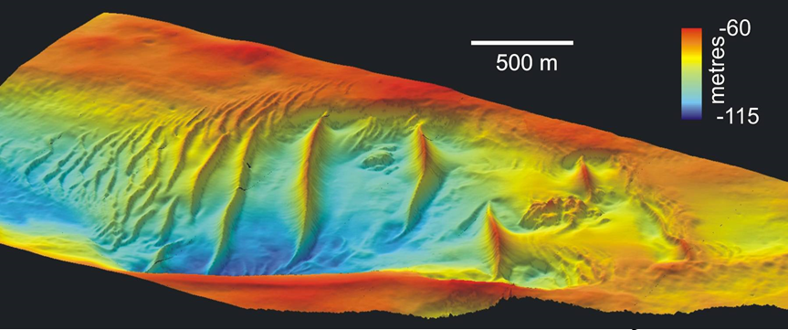
- Multibeam echosounders;
- Bathymetric LiDAR;
The main learning outcomes of BAT are:
- To set-up a bathymetric measurement system, with the knowledge of oceanographic data and seafloor composition;
- To interpret water column data and sounders returns of a bathymetric system from the knowledge of acoustic parameters and environmental conditions;
- To calibrate, apply quality control procedure of acoustic depth measurement systems;
- To set and optimize on-line acoustic parameters of a bathymetric system;
- To calibrate and set the acoustic parameters of a seafloor imaging system; interpret seafloor imaging for obstructions search;
- To describe several non acoustic bathymetry techniques.
- Nautical Science -NSC
-
Content outline:
• Meteorology;
• Seamanship;
• Survey operation and safety at sea;
• Navigation;
• Communications at sea.The main learning outcomes of NsC are:
1. To understand the content of a nautical chart, the impact of data quality on a chart and plot points, routes on a chart;
2. To get awareness of safety and emergency procedures on surveys vessels;
3. To describe and practice instrument mooring, launching and recovery;
4. To describe the main meteorological elements and to produce a short term forecast based on observations.
- Hydrography – HYD
-
Content outline:
This module details the methodology of different types of surveys, review the quality standards which apply to survey data, and describes the different types of survey system and their integration to survey vessels.
- Risk of grounding, different types of hydrographic surveys, introduction to depth measurements;
- Survey systems and survey methodologies;
- Data uncertainty, data quality standards;
- Data acquisition system, integration of hydrographic survey systems;
- Products and reports.
The main learning outcomes of HYD are:
- To execute a survey plan, for various types of hydrographic surveys;
- To understand survey specifications and to check their adequacy with a survey system;
- To install, set-up and calibrate a survey system;
- To understand the source of errors of a survey system and to execute quality control procedure;
- To produce survey documentation.
- Hydrographic Data Processing and Management – HDPM
-
Content outline:
Hydrographic data management comprises data processing and is presented together with professional software tools, like CARIS HIPS/SIPS. The module includes the concepts of GIS, and practicals make uses of the freeware QGIS.
- Raw data and acquisition systems;
- Hydrographic data processing principle;
- Single and multibeam echosounder system data processing;
- Side scan sonar imagery;
- GIS;
- Hydrographic data format, data exchange;
- Nautical charts.
The main learning outcomes of HDM are:
- To process swath echo-sounder systems data from raw data to digital terrain models, in particular to be able to detect systematic errors, and apply data quality assessment methods;
- To process SBES data, apply interpolation methods and evaluate DTM uncertainty;
- To process (compensation, mosaics) side-scan sonar and interpret side-scan images;
- To integrate survey data into a GIS, structure survey data, and manage metadata;
- Produce minutes of bathymetry.
- Law of the sea – LA
-
Content outline:
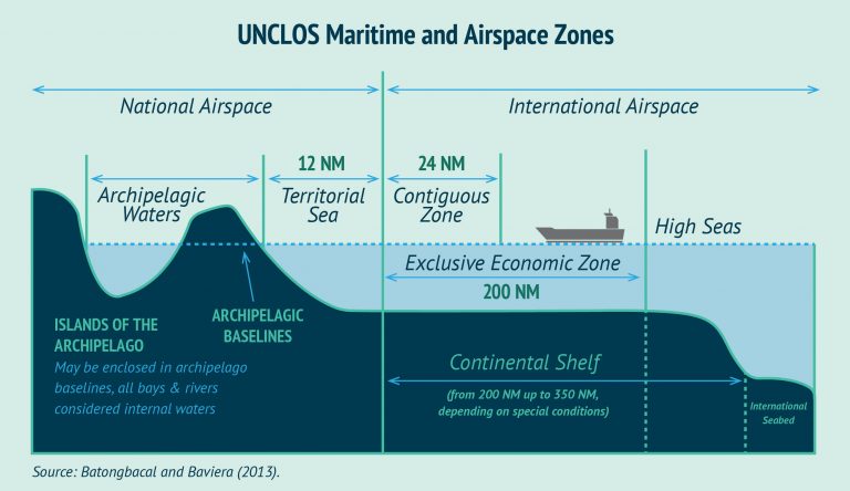
This module presents the essential of the United Nation Convention on the Law Of the Sea (UNCLOS) related to hydrographic activities. It also comprise a description of contract in the framework of hydrographic data production.
- UNCLOS delimitations;
- Liability of the Hydrographic Surveyor.
The main learning outcomes of LAW are:
- Understand the legal aspects related to the work of the hydrographic surveyor (contractual considerations and legal liability);
- Describe the international legal framework in which the hydrographic survey takes place.
For more information, please contact us by email at formation@cidco.ca